 The Miami Conservancy District's flood protection system is known around the U.S. and the world for its unique integrated design.
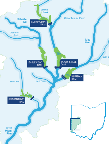
The drainage patterns of the entire Great Miami River Watershed were incorporated into its passive design. The dams and levees operate without human intervention and have no moving parts, except floodgates on storm sewers along the levees. The system includes:
The dams are called 'dry' because they only store floodwaters after heavy rainfall. The remainder of the time, the storage land upstream of each dam – 35,650 acres – is used predominantly for parkland and farmland.
The levees and improved river channels in the 11 cities along the river work together with the dams to protect downstream cities from floodwaters. The levees and channels are designed to carry the flows released by the dams, keeping floodwaters out of the cities.
The flood protection system also utilizes floodplains along the rivers, allowing room for the floodwater flow. Many floodplain areas are preserved so development does not encroach into the floodplain, causing the water to flow faster or deeper.
Click the links below to learn more about each part of the system:
Storage Basins
Levees
Operations & Maintenance
Hydrologic monitoring
Piqua
Troy
Tipp City
Miami Villa (Huber Heights)
Dayton
West Carrollton & Moraine
Miamisburg
Franklin
Middletown
Hamilton
 What the system protects: full vs. partial protection
Throughout the Great Miami River Watershed, the integrated flood protection system protects 22 cities, 5 counties, and 18 townships, and provides multiple benefits.
If a property is protected by dams, storage basins, and levees, it is considered fully protected. If a property is protected by dams and storage basins (no levees in your community), it is considered partially protected, and receive less benefit. Properties that flooded in 1913 and are now protected by the Miami Conservancy District flood protection system pay an annual assessment calculated using several factors including property tax values established by the county auditor.
Full & Partial Protection Maps by County:
Hydrologic Monitoring
Flood protection includes more than the care of infrastructure. The Miami Conservancy District maintains a Hydrologic Monitoring Program to continually evaluate the flood protection system and provide recorded hydrologic data for public use. These networks include a daily Observer Precipitation network, a Stream-Gaging network, and a Real-Time Data network. Additional data and statistics are also recorded during each high-water event in which the dams store water.

Whatever the problems of the Miami Valley and its people will be in the future, floods will not be one of them. But I hope the lessons learned in those harrowing days of the flood itself and in the years which followed will never be forgotten. For they teach far more than how to bridle angry waters... they provide at least one example of what men and women can accomplish when they work together with unconquerable spirit toward a common goal. - Edward A. Deeds, The Miami Conservancy District Board of Directors, 1915-1954
Did You Know?
From 1927 to 1944, the Miami Conservancy District planted over 405,000 trees in the dam storage basins to help restore the land from the construction of the flood protection system.


